-
 Thanh toán đa dạng, linh hoạtChuyển khoản ngân hàng, thanh toán tại nhà...
 -
 Miễn Phí vận chuyển 53 tỉnh thànhMiễn phí vận chuyển đối với đơn hàng trên 1 triệu
 -
 Yên Tâm mua sắmHoàn tiền trong vòng 7 ngày...
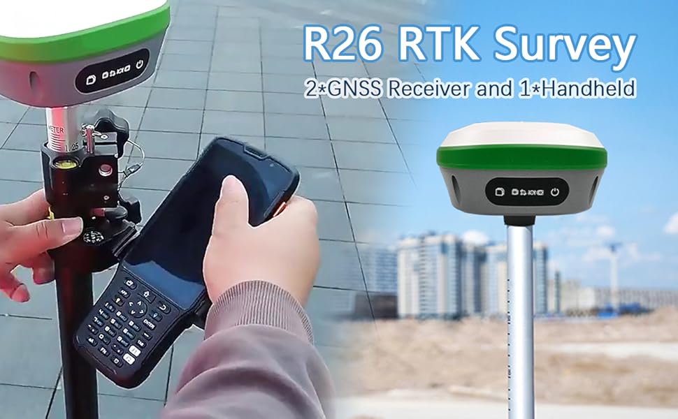
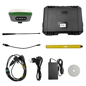
SMAJAYU RTK Surveying System with RTK Rover,Base and Handheld Surveying System Complete for Construction and Geodetic Surveying or Layout Planning Centimeter-Level Measurement Accuracy
-

- Mã sản phẩm: B0BNKZ74QP
- (2 nhận xét)


- ASIN:B0BNKZ74QP
- Best Sellers Rank:#698,870 in Tools & Home Improvement (See Top 100 in Tools & Home Improvement) #1,205 in Levels
- Date First Available:November 29, 2022
Tính năng sản phẩm
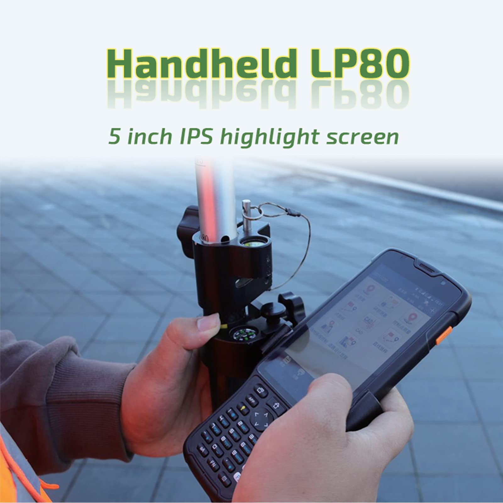
• 【What is it】GNSS Surveying System, consists of R26 RTK surveying system and R26 RTK base station. Double R26 RTK GNSS receiver included, which enables the system to pinpoint measurement and reference locations in a timely and accurate manner. This Survey system is mainly for construction and geodetic surveys or layout planning• 【How to work】:Handheld surveying terminal with professional instruction. High precision, low power consumption, small size, easy to carry and operate. Fully support BDS, GPS, GLONASS, Galileo systems, adapt to a variety of complex and harsh environments, and ensure centimeter-level measurement accuracy.• 【Where to use】 Accuracy RTK GNSS receiver R26 can meet various surveying & engineering, such as surveying and mapping engineering, geographic information, engineering surveying, mine surveying etc.• 【Why to use】 Built-in Blue-tooth, radio, storage, positioning,inertial navigation, antenna and other modules to meet various needs of measurement work. Built-in low-power transceiver integrated radio module, which can realize automatic switching between mobile station and base station• 【R26 Radio Protocol】TRIMTALK、TRIMMK3、TT450S、TRANSEOTMô tả sản phẩm
Product description
RTK Survey
Technology in Surveying: Real-Time Kinematic (RTK) GPS
The use of RTK survey GPS equipment represents the leading edge of innovation in the surveying industry. This device makes use of a real-time kinematic (RTK) GPS, which enables it to pinpoint measurement and reference locations in a timely and accurate manner. RTK GPS survey equipment, such as SMAJAYU, does not need processing after the survey has been finished. It allows for instant response to be provided in the field, giving data on accuracy and quality testing without the need to analyze the survey or return to the area for a do-over. This kind of surveying is advantageous for surveyors since it may be used for both level 3 and level 4 surveys at the same time.
Surveying and Mapping

How does RTK survey GPS work?
- Real-time surveys conduct using RTK GPS survey equipment with either a dual frequency, but the L1 carrier phase is always employed to bring the survey to its successful conclusion. Due to the frequency capabilities, this indicates that RTK surveys can only be undertaken within a radius of around 2 kilometers (km) from the base.
- On the other hand, there are occasions when the whole range is employed for the survey, which necessitates shorter distances in order to keep the accuracy level at 1 centimeter. Utilizing a GPS system is both time and labor-saving, but there is uncertain that the outcomes will match your expectations.
- When doing a survey using RTK GPS technology, a surveyor is limited in what they can accomplish according to the number and location of satellites that are accessible on that particular day. The need to rearrange your calendar to accommodate the satellites may seem to be an additional strain, yet, doing so will really result in an increase in both your productivity and effectiveness.

- FULL CONSTELLATION MULTI-BAND
Fully support BDS, GPS, GLONASS, Galileo systems, adapt to a variety of complex and harsh environments, and ensure centimeter-level positioning accuracy
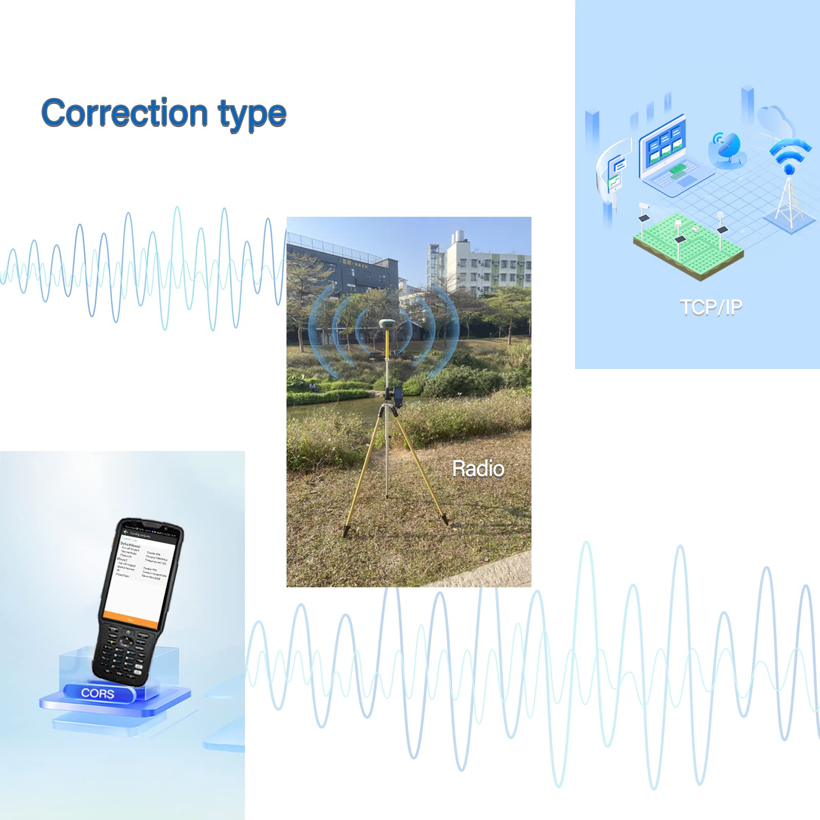
- BUILT-IN UHF RADIO
Built-in low-power transceiver integrated radio module, which can realize automatic switching between mobile station and base station
- LARGE CAPACITY AND LONG BATTERY LIFE
Built-in battery with a capacity of up to 10000mAh, which can achieve more than 14 hours of continuous battery life, ensuring longterm operation in harsh outdoor environments
- STRONG COMPATIBILITY
Adapt to transparent, TRIMTALK, South and so on ,multiple communication protocols
Survey steps


Box1: R26+LP80
R26 GNSS Receiver/ Handheld/ Handheld Bracket/
Handheld Charger/ Power Cable/ Power Adapter/
Nine-core setting line/ Terminal Antenna/ Nine-core to DC cable
(This picture shows all the accessories included in the Box1, please confirm carefully.)
Box2: R26
R26 GNSS Receiver/ Extension rod/ Terminal antenna/
Disc/ Power cable/ Power Adapter/
Nine-core to DC cable/ Nine-core setting line
(This picture shows all the accessories included in the Box2, please confirm carefully.)

Box1 and Box2 are used together

R26 GNSS Receiver multi angle picture
Usage Guidelines

 |  |  |  |  | |
|---|---|---|---|---|---|
| JY100 GPS Guidance System for Tractor | JY305 Auto Steering System | R26 Base System | R26 Rover | R26 base+rover | |
| Model | JY100 | JY305 | R26 Base | R26 Rover | R26 Base+Rover |
| Application | Tractor Guidance | Tractor auto-steering | Base station | GNSS Rover | GNSS Surveying |


 KHUYẾN MÃI LỚN
 Đông Trùng Hạ Thảo
 Hỗ Trợ Xương Khớp
 Bổ Não & Tăng cường Trí Nhớ
 Bổ Sung Collagen & Làm Đẹp
 Bổ Thận, Mát Gan & Giải Độc
 Chăm Sóc Sức khỏe Nam Giới
 Chăm Sóc Sức khỏe Nữ Giới
 Chăm sóc Sức khỏe Trẻ Em
 Thực Phẩm Giảm Cân, Ăn Kiêng
 Bổ Sung Vitamin & Khoáng Chất
 Bổ Tim Mạch, Huyết Áp & Mỡ Máu
 Bổ Mắt & Tăng cường Thị lực
 Điều Trị Tai Mũi Họng
 Sức Khỏe Hệ Tiêu hóa
 Chăm Sóc Răng Miệng
 Chống Oxy Hóa & Tảo Biển.